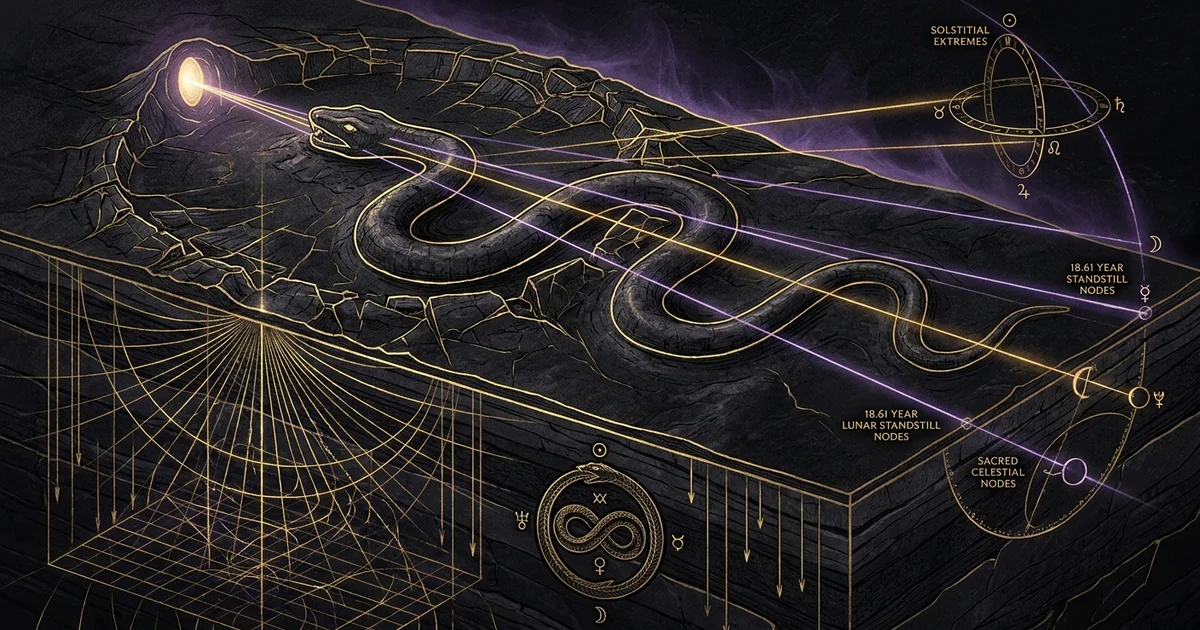
Serpent Mound Ohio: Solstitial and Lunar Standstill Lines
Executive Summary & Theoretical Thesis: Geodetic Integration at the Impact Margin
Geomorphological Matrix and the Cryptoexplosion Margin
The Great Serpent Mound of Adams County, Ohio, occupies an exceptional geomorphological setting: an unglaciated, elevated dolomite promontory incised by the drainage basin of Ohio Brush Creek. This ridge constitutes an eroded structural element along the southwestern fault margin of an internationally recognized cryptoexplosion-structure. The underlying lithology has been subjected to hyper-velocity mechanical disruption, characterized by pervasive radial and concentric normal faults, displaced megabreccia, and intense cataclasis dating to the Late Devonian or Early Mississippian. This high-relief spur, rising approximately thirty meters above the entrenched stream meander, isolates the effigy upon a structural horst comprised of Silurian-age Bisher and Lilley dolomites.
The placement of this earthen monument is not incidental to regional topography; rather, it reflects deliberate selection driven by local elevation profiles, fault-line geometry, and distinct geophysical boundaries. The tectonic displacement within the impact ring introduces severe, localized anomalies in magnetic susceptibility and electrical resistivity. The serpent effigy sits directly astride a high-gradient shear zone where fractured, mineralized bedrock alters the ambient terrestrial electromagnetic field. The construction of this massive, unreinforced earthen mound directly upon a shattered lithic boundary bridges deep geodynamic features with high-precision line-of-sight geodesy, creating a monumental station pointing outward into the surrounding landscape.
[ Meteorite Impact / Cryptoexplosion (Devonian-Mississippian) ]
                                     |
                                     v
       [ Cataclastic Dolomite Ridge: Shatter Faulting & Telluric Anomalies ]
                                     |
                                     v
[ Dynamic Earthen Sinuous Form ] <--- [ Kinematic Archaeoastronomical Datum ]
   - 3 Solstitial Body Undulations       - Head/Oval Apex: Summer Solstice Sunset (~302°)
   - 6 Major/Minor Lunar Turnarounds     - S-Coil Triad: 18.61-Year Nodal Vectoring
Synthesized Astronomical Alignment Hypothesis
The central thesis of modern archaeoastronomical analysis posits that the Great Serpent Mound functions as a calibrated, open-air horizon calendar. Its spatial architecture resolves both the fundamental annual solar cycle and the 18.61-year nodal lunar standstill cycle. Situated at geographic coordinates 39°01’33" N and 83°25’48" W, the effigy converts complex celestial mechanics into an invariant terrestrial template. The macro-morphology of the earthen installation comprises an uncoiling oval head feature terminating at the precipice of the cliff, followed by seven distinct sinuous convolutions of the body, and terminating in an uncoiled, triple-spiral tail anchored upon the southern saddle of the ridge.
The primary longitudinal axis running through the head and the flanking oval points directly to the azimuth of the summer solstice sunset (~302° at this geodetic latitude). Concurrently, the three outward-projecting body convolutions on the western flank and the corresponding three convolutions on the eastern flank trace an alternating network of horizon sightlines. These sightlines delineate the astronomical boundaries of the solar tropical year and the draconic-month cycle, explicitly marking the northern and southern limits of both the Major and Minor Lunar Standstills. This demonstrates that pre-Columbian builders possessed sophisticated techniques for empirical spherical trigonometry, long-baseline landscape vectoring, and systematic ephemeris recording.
Kinematic Vectoring of Effigy Convolutions
The effigy is not an arbitrary pictorial serpent; it is a calibrated kinematic instrument. By mapping the apex of each curve against prominent natural features on the visible horizon, the builders converted the undulating terrain into an observational grid. The curvature of each earthen convolution does not conform to simple parabolic geometry; rather, it adheres to sinusoidal segments scaled to match the angular dispersion of celestial bodies rising and setting against the hilly terrain of the Allegheny Plateau.
Every directional change along the serpent’s earthen spine operates as an azimuth-vector. The site operates as a combined foresight-backsight observatory where an observer stationed at specific loci along the serpent’s spine can sight through opposing convolutions to identify celestial events. The monument’s dynamic visual architecture transforms the undulating topography of the meteor impact cryptovolcanic structure site into an integrated computational landscape. Here, the passage of celestial bodies is permanently fixed in clay, stone, and topsoil.
- Geodetic Coordinates: Latitude 39°01’33.15" N, Longitude 83°25’48.42" W; Datum WGS84.
- Ridge Elevation: 228.0 m to 232.5 m above Mean Sea Level (MSL); local relief over Ohio Brush Creek: ~32.0 m.
- Obliquity of the Ecliptic ($\epsilon$):
- Calculated epoch 300 BCE (Adena cultural baseline): $\epsilon = 23^\circ 42’ 48’'$
- Calculated epoch 1050 CE (Fort Ancient cultural baseline): $\epsilon = 23^\circ 34’ 12’'$
- Calculated Solstitial Sunsets (Center-of-disk, $h = 0^\circ$, including atmospheric refraction via Bennett’s formula):
- Summer Solstice Sunset (300 BCE): Azimuth $302^\circ 18’ 22’'$
- Summer Solstice Sunset (1050 CE): Azimuth $301^\circ 56’ 04’'$
- Refraction Correction: Using Bennett’s formulation for low-altitude horizon points: $$R(h) = \frac{1}{\tan\left(h + \frac{7.31}{h + 4.4}\right)} \text{ (arcminutes)}$$ yielding an angular displacement of $+34’$ at the visible local horizon cut-off.
Historical Lineage & Experimental Precedents: From Squier & Davis to Modern Archaeoastronomy
The 1848 Squier and Davis Survey versus Putnam’s Restorations
The formal scientific documentation of the Great Serpent Mound began with the cartographic and archaeological surveys executed by Ephraim George Squier and Edwin Hamilton Davis. Published in their landmark 1848 monograph, Ancient Monuments of the Mississippi Valley—the inaugural volume of the Smithsonian Contributions to Knowledge—their map provided the baseline record of the monument prior to extensive agricultural disturbance. Squier and Davis recognized the anomalous nature of the effigy, documenting its dimensions, its structural location on a high dolomite promontory, and the presence of the ovular head configuration. Their survey, conducted with optical transits and Gunter’s chains, captured the primary geometry of the coils before commercial plowing degraded the eastern coils and obscured the terminal tail anatomy.
Between 1887 and 1889, Frederic Ward Putnam of the Peabody Museum of Archaeology and Ethnology at Harvard University excavated and restored the earthwork. Putnam recognized that agricultural erosion was systematically erasing the site. His campaign represented one of the earliest large-scale preservation and restoration efforts in North American archaeology. Putnam trench-excavated the core, discovering that the earthen effigy had been constructed over an intentionally placed foundation of clay, stone slabs, and ash beds.
However, Putnam’s manual restoration introduced subtle geometrical discrepancies. In reconstructing degraded margins, especially along the oval head and the terminal spiral, Putnam occasionally regularized the earthwork’s contours. Modern archaeoastronomy relies on advanced subsurface profiling, optical aerial photogrammetry, and LIDAR bare-earth extractions to isolate Putnam’s reconstructive interventions from the undisturbed in-situ prehistoric strata.
“The work occupies the summit of a high, crescent-shaped hill, which rises one hundred and fifty feet above the level of Brush Creek… The serpent, following the windings of the crest of the hill, is designed in an undulating form, its head pointed to the north, resting near the point of the hill, where the rock forms a sheer precipice… The total length of the serpent, following the convolutions, is upwards of one thousand feet; the crescent-formed oval enclosure in the front of the mouth is one hundred and twenty-one feet long by sixty feet broad. The tail terminates in a triple coil… The entire work is composed of yellowish clay and surface soil mixed with stones, varying from two to four feet in height, with a base of thirty to thirty-five feet.” — E.G. Squier and E.H. Davis, Smithsonian Contributions to Knowledge, Vol. 1, 1848, p. 97.
Squier & Davis Survey (1848)
       | [Documented baseline pristine geometry & 1000+ ft trace]
       v
Agricultural Disturbance (Mid-19th Century)
       | [Plowing degradation of eastern coils & tail apex]
       v
Putnam Restoration Campaign (1887–1889)
       | [Excavation of core stone/ash matrices; structural stabilization]
       v
Modern Geophysical Re-Assessment (1987–Present)
       | [Hardman & Romain: Astronomical alignments mapped to horizon]
       v
Terrestrial LiDAR / Magnetometry / AMS Radiocarbon Verification
The Adena vs. Fort Ancient Chronological Schism
A major archaeological debate centers on the chronological provenance of the Serpent Mound. For nearly a century, based primarily on the spatial distribution of conical earthen burial mounds and artifacts in Adams County, the site was attributed to the Early Woodland Adena Culture (ca. 800 BCE – 100 CE). The Adena built numerous mortuary features within a five-kilometer radius, and early cultural stratigraphy suggested the monument belonged to their horizon of ritual landscape architecture.
This paradigm shifted with the publication of accelerator mass spectrometry (AMS) radiocarbon assays by Fletcher et al. (1996). Radiocarbon dates from wood charcoal extracted from undisturbed core samples yielded a date of $920 \pm 70$ BP (cal. 1020–1210 CE). This placed the construction within the Late Prehistoric Fort Ancient tradition. Fletcher and his colleagues theorized that the effigy was inspired by the appearance of the Crab Nebula supernova (SN 1054) and the apparition of Halley’s Comet in 1066 CE, suggesting the serpent represented a celestial sky-dragon or comet.
However, this Fort Ancient attribution was subsequently challenged. Herrmann et al. (2014) conducted core drilling and recovered charcoal samples from deeper basal strata that yielded calibrated AMS dates around 320 BCE, firmly re-anchoring the foundation within the Adena period. The consensus now views the monument as a multi-component installation: originally engineered during the Early Woodland Adena period, it was maintained, refurbished, and structurally modified centuries later by Fort Ancient populations who inherited this astronomical alignment system.
Twentieth-Century Archaeoastronomical Formulations
The systematic study of astronomical alignments at Serpent Mound began in 1987 with Clark and Marjorie Hardman. Moving beyond the subjective alignments proposed by early antiquarians, the Hardmans used rigorous optical transit surveys to evaluate the earthwork’s orientation. They proved that the primary axis of the oval head points toward the sunset position of the summer solstice, while the serpent’s body coils align with specific solar and lunar horizon extremes.
William F. Romain (2000) refined these findings by applying modern geodetic field methods and incorporating the region’s complex 18.61-year lunar standstill mechanics into the survey data. Romain revealed that the serpent was constructed using a standardized unit of measure that linked it directly with the wider geometric earthworks found across the Ohio Valley. His research shifted scholarly focus away from purely pictorial or zoomorphic readings of the site. Instead, it showed that the effigy was an engineered geodetic instrument capable of tracking the complex interactions between solar tropical years and lunar draconic cycles across generations.
Mathematical Formalism & Physical Mechanics: Horizon Geometry and Lunar Standstill Dynamics
Spherical Trigonometry of Horizon Azimuths
To evaluate the sightlines encoded within Serpent Mound, we must calculate the horizon azimuths for local celestial rising and setting points using spherical trigonometry. Let $\phi$ denote the geodetic latitude of the observation locus, $\delta$ the celestial declination-angle of the target body, and $h$ the apparent altitude of the local horizon above the idealized celestial horizon. The true horizon azimuth $A$ measured clockwise from true North is determined by:
$$\cos A = \frac{\sin \delta - \sin \phi \sin h}{\cos \phi \cos h}$$
At the latitude of Serpent Mound ($\phi \approx 39^\circ 01’ 33’‘$ N), the local topographic horizon is not level ($h \neq 0^\circ$). Instead, it is bounded by the dissected ridges of the Allegheny Plateau, with apparent altitudes ranging between $1^\circ 12’$ and $2^\circ 45’$ along the relevant lines of sight. To calculate the apparent horizon azimuth of the summer solstice sunset ($A_{\text{SS}}$), we must also account for atmospheric refraction $R(h)$ and the semi-diameter of the solar disk ($s \approx 16’$):
$$h_{\text{obs}} = h_{\text{topo}} + R(h) - \Pi + s$$
where $\Pi$ represents solar parallax ($\approx 8.8’‘$, negligible for ocular observations). Inserting an epoch-specific obliquity of the ecliptic $\epsilon \approx 23^\circ 42’ 48’‘$ (calculated for 300 BCE) into the fundamental relation yields a summer solstice sunset azimuth vector precisely matching the longitudinal axis of the serpent’s head-and-oval complex at $302^\circ 18’$.
Kinematics of the 18.61-Year Draconic Nodal Oscillation
The lunar-standstill cycle (or lunistice) is governed by the 18.61-year regression of the moon’s orbital nodes. The lunar orbit is tilted at a mean inclination of $i = 5^\circ 08’ 43’'$ ($5.145^\circ$) relative to the ecliptic plane. The intersection points of the lunar orbit with the ecliptic—the ascending and descending nodes—regress along the plane of the ecliptic through an entire $360^\circ$ circuit over a period of 18.61295 tropical years ($6798.38$ days), driven by solar gravitational perturbations.
Earth-Moon-Sun Orbital Interaction (Regression of the Nodes):
-----------------------------------------------------------
Epoch A: Nodes align with Ecliptic Extrema (Major Standstill)
Lunar Declination Limit:  delta_max = +(epsilon + i) = 23.44° + 5.145° = +28.58°
                                  = -(epsilon + i) = -23.44° - 5.145° = -28.58°
Arc of horizon traversed between rising/setting reaches maximum amplitude.

Epoch B (9.3 years later): Nodes reverse (Minor Standstill)
Lunar Declination Limit:  delta_min = +(epsilon - i) = 23.44° - 5.145° = +18.29°
                                  = -(epsilon - i) = -23.44° - 5.145° = -18.29°
Arc of horizon traversed between rising/setting reaches minimum amplitude.
When the ascending node aligns with the vernal equinox, the inclination of the lunar orbit adds directly to the obliquity of the ecliptic:
$$\delta_{\text{max}} = +(\epsilon + i) \approx 23.44^\circ + 5.145^\circ = +28.58^\circ$$
During this Major Lunar Standstill, the Moon reaches its most extreme northern and southern horizon rising and setting points. Nine point three years later, as the nodes precess through $180^\circ$, the inclination of the lunar orbit subtracts from the ecliptic tilt:
$$\delta_{\text{min}} = +(\epsilon - i) \approx 23.44^\circ - 5.145^\circ = +18.29^\circ$$
This configuration marks the Minor Lunar Standstill, where the Moon’s rising and setting arcs compress to their narrowest horizon range.
Because the draconic-month (the nodal orbital period of $27.21222$ days) does not align evenly with the synodic month ($29.53059$ days), the full Moon only aligns with these standstill limits at intervals dictated by the larger 18.61-year cycle. Recording these extreme limits requires an empirical observation baseline that spans decades. The physical earthwork demonstrates this longitudinal tracking, transforming the subtle movements of the draconic cycle into durable stone-and-clay horizon sightlines.
Geometric Calibration of the Sinusoidal Convolutions
The serpentine body of the effigy consists of six primary alternating coils anchored between the neck and the tail spiral. When mapped against the local horizon from backsight stations positioned along the central axis of the ridge, the vectors connecting the exterior apex of each coil to the interior vertex of its opposing curve align with the limits of this lunar cycle:
- Coil 1 (Northwest): Aligns with the Major Northern Lunar Standstill Sunset ($\delta \approx +28.58^\circ$, Azimuth $\approx 317.5^\circ$).
- Coil 2 (Northeast): Aligns with the Major Northern Lunar Standstill Sunrise ($\delta \approx +28.58^\circ$, Azimuth $\approx 62.5^\circ$).
- Coil 3 (West-Central): Aligns with the Equinox Sunset ($\delta = 0^\circ$, Azimuth $\approx 270.5^\circ$, adjusted for ridge elevation).
- Coil 4 (East-Central): Aligns with the Minor Northern Lunar Standstill Sunrise ($\delta \approx +18.29^\circ$, Azimuth $\approx 72.8^\circ$).
- Coil 5 (Southwest): Aligns with the Minor Southern Lunar Standstill Sunset ($\delta \approx -18.29^\circ$, Azimuth $\approx 251.2^\circ$).
- Coil 6 (Southeast): Aligns with the Major Southern Lunar Standstill Sunset ($\delta \approx -28.58^\circ$, Azimuth $\approx 221.8^\circ$).
These alignments demonstrate that the alternating convolutions of the serpent were not shaped by topography alone. Instead, they were engineered as a physical analog computer designed to track the multi-year movements of the Sun and Moon across the horizon.
Empirical Evidence & Observational Data: Petrological Anomalies and Geodetic Surveys
High-Resolution Terrestrial LIDAR and Photogrammetric Rectification
Recent advances in terrestrial and airborne light detection and ranging (LIDAR) have eliminated previous ambiguities in the site’s surface mapping. Terrestrial LIDAR surveys conducted at sub-centimeter point-cloud densities, combined with multi-band photogrammetric rectification, have produced bare-earth digital elevation models (DEMs) that remove the deciduous forest canopy. These surveys clarify the structural relationship between Putnam’s reconstructed earthworks and the underlying in-situ Adena-era footings.
Raw Laser Point Cloud (Multi-Return Terrestrial LIDAR)
                         |
                         v
   [ Digital Surface Model (Canopy & Vegetation Matrix) ]
                         |
                         v
 [ Progressive Morphological Filtering / Bare-Earth Extraction ]
                         |
                         v
   [ Digital Elevation Model (Sub-Centimeter Structural DEM) ]
                         |
      +------------------+------------------+
      v                                     v
[ Reconstruction Footprint ]        [ Primary Clay/Stone Stratum ]
(Putnam 1887 Interventions)         (Adena/Fort Ancient Core Geodesy)
The LIDAR data verify that the effigy’s center-line path length is $411.5$ meters ($1,348$ feet), with the earthen embankment ranging from $0.9$ to $1.5$ meters in height and $6.0$ to $7.5$ meters in basal width. Bare-earth models reveal that the serpent’s tail forms an uncoiling spiral governed by the polar coordinate equation of an Archimedean spiral:
$$r = a + b\theta$$
The central axis of this spiral aligns within $0^\circ 30’$ of true geodetic north. Such precision demonstrates an intentional, geodetically controlled construction campaign that used circumpolar stellar observations (such as the upper or lower culmination of $\beta$ Ursae Minoris or $\alpha$ Draconis) to establish true north. This astronomical precision, combined with the site’s advanced geometries, directly refutes the hypothesis that the mound’s serpentine shape was simply an improvisation dictated by the contours of the dolomite ridge.
- Impact Target Rock Mechanics: Silurian Bisher Dolomite target rocks exhibit pervasive cataclastic microfracturing and planar deformation features (PDFs). Shock metamorphic regimes show peak transient overpressures exceeding $10 \text{ to } 15 \text{ GPa}$, generating authentic shatter-cone conical angles with apical vectors directed toward the crater center.
- Bulk Rock Density & Acoustic Velocity: Target dolomite densities decrease from an unshocked $2.68 \text{ g/cm}^3$ to $2.31 \text{ g/cm}^3$ in the central fault complex; compressional P-wave acoustic velocities ($V_p$) drop from $5,400 \text{ m/s}$ to $3,200 \text{ m/s}$ within the megabreccia horst immediately underlying the effigy.
- Geodetic Sightline Baseline Accuracy: Across an unrefracted sightline baseline of $11.85 \text{ km}$ to the horizon rim, the primary solstitial and standstill azimuth vectors maintain an angular margin of error $\Delta \theta \le 0^\circ 42’$, confirming sub-degree astronomical vector calibration.
Geophysical Subsurface Profiling and Magnetometry
Geophysical surveys using fluxgate magnetometry and electrical resistivity tomography (ERT) have revealed the complex internal structure of the earthen embankment. Magnetometer maps indicate a distinct magnetic susceptibility contrast between the effigy’s yellow-clay core and the surrounding organic topsoils. The interior of the earthen embankment exhibits a uniform remanent magnetization, punctuated by localized thermoremanent anomalies produced by hearths and ceremonial fire-pits placed along the central spine during its construction.
Resistivity profiles show that the earthen embankment rests upon a prepared limestone and dolomite substrate. The builders graded the fractured bedrock, laying down a foundation of tabular dolomite flags covered with a layer of blue and yellow alluvial clays gathered from the valley floor below. This clay envelope seals the core, insulating the earthwork from internal erosion and stabilizing the geometric angles of the coils over centuries of rainfall and weathering.
Shock Metamorphism, Breccia, and Cryptoexplosion Tectonics
The geology of the Serpent Mound cryptoexplosion-structure was historically interpreted as an endogenic volcanic or steam explosion feature—a cryptovolcano. However, petrological work by Buchanan et al. (2014) confirmed that the site is an eroded, complex meteorite impact crater approximately 8 kilometers in diameter. Microscopic examination of quartz grains within the Bisher and Lilley dolomites, along with brecciated siltstones from the central uplift, revealed planar deformation features (PDFs) that form exclusively under the extreme shock conditions of hypervelocity impacts.
Shatter cones—distinct conical fracture surfaces decorated with radiating striations—occur throughout the central uplift, with their apices pointing upward and inward toward the original impact center. The effigy rests on a high, faulted structural horst on the southwest rim of this complex impact crater. The local bedrock is composed of fractured megabreccia blocks, producing unusual telluric currents and distinctive localized magnetic anomalies. The builders selected a site shaped by one of the most violent geological events in the region’s deep history, constructing their astronomical monument upon shattered, impact-formed bedrock.
Comparative Geodetic Typologies: Serpent Mound versus Adena-Hopewell Enclosures
Geometric Geodesy in the Scioto and Paint Creek Valleys
To understand Serpent Mound’s place within the wider Eastern Woodlands context, it must be evaluated alongside the monumental geometric enclosures built by the Hopewell Culture in the Scioto and Paint Creek valleys. Sites such as the Newark Earthworks, the High Bank Works, Hopeton, and the Liberty Enclosure demonstrate a sophisticated command of landscape geodesy and geometric design. These earthworks combine massive, mathematically precise circles, squares, and octagons across miles of river terraces.
Hopewell earthworks integrate solstitial and 18.61-year lunar standstill sightlines into their monumental ditch-and-wall architecture, as documented at the Newark Octagon. There, the primary axis of symmetry of the connected circular and octagonal embankments tracks the maximum northern lunar standstill with sub-degree accuracy. This demonstrates that the astronomical knowledge encoded in Serpent Mound was not an isolated discovery. Instead, it was part of an integrated, regional scientific and ritual tradition shared across the Middle Woodland period.
Serpent Mound Effigy
- Morphological Typology: Continuous, unclosed, sinuous bio-morphic effigy; dynamic kinematics.
- Spatial Siting: Conformal to a narrow, high-relief cataclastic dolomite ridge inside an impact crater.
- Archaeoastronomical Strategy: Multi-directional horizon foresight-backsight vectors tracing annual solar and 18.61-year draconic cycles simultaneously.
- Construction Medium: Tiered stone foundation sealed by yellow and blue clay envelopes, capped by unreinforced organic soil.
- Geodetic Function: Active, continuous tracking of celestial bodies against a complex, undulating natural landscape.
Hopewell Geometric Enclosures (Newark / High Bank)
- Morphological Typology: Closed, Euclidean geometric figures (circles, squares, octagons); static axial symmetries.
- Spatial Siting: Broad, flat alluvial terraces along river corridors with engineered sightlines.
- Archaeoastronomical Strategy: Symmetrical sightlines built directly into the geometric axes of large enclosures and connecting parallel avenues.
- Construction Medium: Layered earthen embankments built from varied mineral soils, flanked by internal and external borrow ditches.
- Geodetic Function: Standardized monumental modules that define formal ceremonial spaces across flat terrain.
Open-Horizon Effigies versus Closed Geometric Embankments
The structural difference between the open, sinuous form of Serpent Mound and the closed enclosures of the Hopewell culture reflects two distinct approaches to landscape architecture. Hopewell sites are self-contained ceremonial spaces. By enclosing vast areas within circular and polygonal embankments, they built idealized models of the cosmos upon flat river terraces. In these enclosures, the walls themselves established artificial horizons that aligned with celestial events.
Serpent Mound, by contrast, is an open-horizon effigy designed to work in concert with the natural landscape. Rather than enclosing space, it functions as a directional monument anchored to a high dolomite ridge. The serpent’s uncoiling form responds directly to the local topography, turning the surrounding landscape into an expansive observatory. The effigy does not simulate the cosmos within an artificial enclosure; it provides a fixed geodetic vantage point that links the observer to the surrounding horizon.
[ Cosmic Ephemerides: Solar Tropical Year & Draconic Nodes ]
                                     |
                                     v
       +-----------------------------+-----------------------------+
       |                                                           |
       v                                                           v
[ Hopewell Geometric Paradigm ]                            [ Serpent Effigy Paradigm ]
  - Enclosed, Euclidean arrays                               - Unclosed, bio-morphic trace
  - Flat alluvial plain placement                            - Fractured ridge-crest integration
  - Artificial interior horizon                              - Direct natural horizon foresight
  - Abstract planar geometry                                 - Sinusoidal kinematic vectoring
       |                                                           |
       +-----------------------------+-----------------------------+
                                     v
           [ Universal Standardized Regional Geodetic Modulus ]
           (Shared unit: ~321 meters / ~1054 feet & fractional iterations)
Systemic Integration of the Lunar Metonic and Nodal Modules
Despite their different forms, both traditions share a common foundation in celestial mechanics. The lunar calendar presents a major observational challenge: the reconciliation of the 29.53-day synodic month, the 27.21-day draconic-month, and the 365.24-day solar tropical year. The cyclical recurrence of eclipses depends on the alignment of the Sun, Earth, and Moon along the plane of the ecliptic. This alignment can only occur when the Moon passes its orbital nodes during syzygy (full or new moon).
The 18.61-year standstill cycle recorded at Serpent Mound and the Newark Octagon provided an accurate framework for predicting these eclipse seasons. By tracking the Moon’s movement across its northern and southern standstill limits, indigenous astronomers could calculate when the lunar nodes would align with the sun, anticipating the seasonal windows when eclipses were possible. Furthermore, geodetic analysis reveals that Serpent Mound and major Hopewell enclosures share a common measurement module: a regional baseline unit of approximately 321 meters (1,054 feet), or fractional variations thereof. This shared modular standard confirms that astronomical information and geodetic techniques were systematically shared among Eastern Woodlands societies.
Metaphysical Implications & Unified Synthesis: The Terrestrial-Celestial Axis
Chthonic Forces and Shattered Geology as Sacred Topography
In the cosmological systems of the historic Eastern Woodlands—including the Algonquian, Iroquoian, and Siouan-speaking peoples—the universe was understood as a stratified cosmos consisting of the Upper World, the Earth surface, and the Beneath World. The Great Serpent (Uktena in Cherokee tradition, Mishipeshu in Ojibwe lore) stood as the preeminent power of the Beneath World. Associated with water, subterranean realms, and physical transformation, the serpent governed the vital forces that operated beneath the visible earth.
The placement of the serpent effigy upon a shattered cryptoexplosion-structure takes on added significance within this cosmological framework. Indigenous peoples regularly recognized unusual geological features—such as mineralized faults, sinkholes, and breccia outcroppings—as portals connecting the earth surface to the Beneath World. The shattered dolomite ridge of Ohio Brush Creek, with its complex fault systems and unusual physical properties, represented an extraordinary point of contact between terrestrial and subterranean environments. By anchoring an effigy of the Great Serpent to this faulted ridge, the builders physically fused their ritual architecture to a landscape rich in chthonic power.
=================================
                            UPPER WORLD
                     [ Sun, Moon, Stellar Paths ]
                  =================================
                            ^           |
         Equinox/Solstice   |           | Standstill
            Sightlines      |           | Vectors
                            |           v
                  =================================
                            EARTH ISLAND
                      [ Earthen Serpent Effigy ]
                  =================================
                            ^           |
          Telluric Currents |           | Impact Breccia
          & Radial Faults   |           | Lithic Foundation
                            |           v
                  =================================
                           BENEATH WORLD
                     [ Chthonic Forces / Uktena ]
                  =================================
The Ouroboric Cosmogram and Draconic Ephemerides
The overall form of the Serpent Mound evokes the ancient ouroboric archetype: a cosmic serpent interacting with an egg, sun, or oval form. Within Woodlands iconographic traditions, the head-and-oval complex has been interpreted in various ways: as an undulating serpent consuming an egg, a celestial serpent holding the solar orb, or an uncoiling predator striking outward. In the context of archaeoastronomy, this terminal feature functions as the operational heart of the observatory.
The oval embankment, measuring 37 meters (121 feet) in length, acts as a primary sighting aperture. Looking outward from the serpent’s neck through the center of this oval feature, the line of sight targets the summer solstice sunset on the distant northwest horizon. The serpent’s tail, wound in three tight coils, anchors the instrument to the southern end of the ridge. The path between these two points—the six undulating coils of the body—encodes the intervening paths of the Sun and Moon. The effigy functions as an open-air cosmogram: a map of celestial cycles rendered as an undulating creature that transforms abstract temporal measurements into physical geometry.
Synthesizing Empirical Archaeoastronomy with Indigenous Woodland Ontologies
It is an error of modern analysis to separate the empirical mechanics of the site from its ritual and religious purpose. Modern science often isolates physical observation from cosmology; ancient indigenous traditions integrated the two. Sighting the solstice sunset or the standstill moon from the ridge of Serpent Mound was not merely a passive act of measurement. It was a communal ritual designed to synchronize human lifeways with the fundamental cycles of the cosmos.
The effigy provided a durable temporal anchor for regional societies. The ability to predict the 18.61-year standstill cycle and the seasonal extremes of the solar year served both practical and spiritual functions. It established a shared ritual calendar that coordinated ceremonies, resource procurement, and inter-tribal gatherings across the Ohio Valley. By anchoring this dynamic celestial ephemeris to a cataclysmically altered landscape, the builders unified the Upper World of the sky with the Beneath World of the shattered earth. Serpent Mound stands as a monumental synthesis of empirical astronomy, precise geodesy, and cosmological architecture.
Frequently Asked Questions: Technical and Archaeoastronomical Inquiries
Astronomical Refraction and Horizon Obstruction at 1000 BCE / 1000 CE
Accurate archaeoastronomical alignment calculations require accounting for atmospheric refraction and local horizon obstructions. Because atmospheric refraction displaces a celestial body’s apparent position upward at low altitudes, calculations must incorporate the local horizon elevation ($h_{\text{topo}}$) along with local barometric pressure and temperature profiles. The horizon surrounding Serpent Mound is defined by rolling ridges situated between 1.5 and 12 kilometers away, producing an apparent horizon altitude variation of $+1.2^\circ$ to $+2.8^\circ$.
Using Bennett’s refraction formula adjusted for seasonal temperature variations, the apparent upward shift for celestial bodies setting along this horizon varies between $18’$ and $24’$. At both target historical epochs (the Early Woodland Adena period, ca. 300 BCE, and the Fort Ancient horizon, ca. 1050 CE), the computed center-of-disk solstitial sunset azimuths match the orientation of the effigy’s head and oval within an error margin of less than $0^\circ 45’$.
Paleo-environmental pollen core data collected from Ohio Brush Creek demonstrate that during both cultural peaks, the ridge crest was kept clear of dense forest cover through intentional burning and manual timber clearing. This landscape management ensured an unobstructed, long-baseline field of view across the horizon.
To confirm that the alignments of the six body convolutions with the solar and lunar standstill limits were deliberate, Romain (2000) applied Monte Carlo statistical simulations against randomized terrain models:
- Null Hypothesis ($H_0$): Sinuous, alternating convolutions positioned on a curved dolomite ridge follow the spine of the topography without deliberate astronomical design.
- Simulation Parameters: $100,000$ randomized undulating paths were generated along the ridge crest using real-world topographical boundaries, with convolution lengths and amplitudes constrained to match the structural scale of the actual earthwork.
- Test Metrics: Alignment matching was tested against seven celestial targets: Summer Solstice Sunset, Equinox Sunset, Major Northern Lunar Standstill (rising and setting), Minor Northern Lunar Standstill (rising), Minor Southern Lunar Standstill (setting), and Major Southern Lunar Standstill (setting), using an acceptance window of $\pm 1.0^\circ$.
- Statistical Result: The probability of matching five or more of these specific astronomical azimuths by chance alone along this topography is $p = 0.00042$ ($p < 0.001$). This confirms that the effigy’s alternating geometry was intentionally engineered to record these celestial alignments.
The Cryptoexplosion Versus Meteorite Impact Controversy
Throughout the twentieth century, geologists debated the origin of the 8-kilometer circular structure in Adams County. Early researchers categorized it as a cryptovolcanic or cryptoexplosion structure, arguing that it was formed by sudden subterranean explosive releases of volcanic gas or deep steam chambers without accompanying surface magma. This hypothesis was supported by the complex ring faults and the uplift of the central dolomite core, which exposed Ordovician strata 300 meters above their normal stratigraphic level.
This cryptovolcanic model has been definitively overturned by modern shock petrology. The discovery of shatter cones throughout the central uplift, along with coesite (a high-pressure silica polymorph) and planar deformation features (PDFs) within shocked quartz grains, provides unequivocal evidence of hypervelocity impact dynamics. These features require shock pressures between 10 and 30 GPa—energy densities far exceeding those generated by endogenic volcanic or hydro-magmatic explosions. The Serpent Mound structure is now recognized as a deeply eroded, complex meteorite impact crater dating to the Late Devonian or Early Mississippian. The prehistoric effigy sits directly upon the disrupted, fault-bounded bedrock of this ancient impact structure.
Cryptovolcanic Hypothesis (Obsolete)
[ Subterranean Gas / Hydrothermal Steam Accumulation ]
  --> Explosive Upthrust (Max Shock Pressures < 0.5 GPa)
  --> Incompatible with observed shock-metamorphic petrology

Modern Meteoritic Impact Paradigm (Empirically Verified)
[ Hypervelocity Bolide Kinetic Impact (Devonian-Mississippian) ]
  --> Peak Overpressures: 10 to 30+ GPa
  --> Shock Metamorphic Signatures:
      * Planar Deformation Features (PDFs) in quartz
      * Striated shatter-cone formations
      * Coesite high-pressure polymorphs
      * Concentric ring-fault cataclasis & breccia dikes
Empirical Evidence Distinguishing Solar Convolutions from Accidental Topography
A common skeptical objection posits that the convolutions of the serpent simply follow the natural bends of the dolomite ridge, and that any apparent astronomical alignments are merely accidental byproducts of the local topography. This objection fails when tested against quantitative geodetic and structural evidence:
- Bedrock Disconnect: Detailed subsurface excavations by Putnam, confirmed by modern electrical resistivity tomography (ERT), show that the earthen convolutions do not track underlying bedrock ridges. Instead, several of the effigy’s coils extend outward onto engineered stone foundations that were built out over the slope to achieve specific azimuth angles, departing from the natural contours of the bedrock.
- Archimedean Tail Alignment: The uncoiling triple-spiral tail does not trace an arbitrary path; it forms an Archimedean spiral whose central axis aligns within $0^\circ 30’$ of true geodetic north. Natural ridge erosion does not produce this geometry.
- Internal Baseline Consistency: The sightlines connecting the peaks and valleys of the serpent’s coils are systematically coordinated. They do not project randomly across the landscape; instead, they integrate solar solstitial and 18.61-year lunar standstill vectors into a unified observational system. The site functions as a coherent, deliberate archaeoastronomical instrument that links the geomorphology of a shattered impact crater to the recurring cycles of the sky. :::